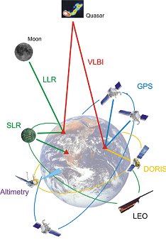
Integration of Space Geodetic Techniques as the Basis for a Global Geodetic-Geophysical Observing System (GGOS-D)
A global monitoring of the Earth from space is of crucial importance to obtain a better understanding of the processes in the complex system Earth. Such an exact knowledge of the processes is the prerequisite to develop geophysical models that, by adjusting and tuning them to the course of events in the past, might eventually allow an extrapolation to the future and thus a prevention of natural hazards and catastrophes.The overall objective of the project is the investigation of the technological, methodological and information-technological realization of a global geodetic-geophysical observing system. The main fields of research are the development and implementation of data collection and data management systems as well as the generation of consistent and integrated geodetic time series for the description and modeling of the geophysical processes in the Earth system. The time series have to be referred to a unique, extremely accurate reference frame, stable over decades, and should be generated in such a way that they can be made available in near real-time to all users in science and society. Methods for a careful internal and external validation will guarantee a very high reliability. The project is coordinated by Prof. Dr. Markus Rothacher, GeoForschungsZentrum Potsdam. |
|

